Pinnacle Mountain Tower Trail
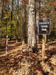 The USDA Forest Service Trail #25 "Pinnacle Mountain Tower Trail" to the renovated 40-ft
Pinnacle Fire Tower observation platform provides a 360-degree panoramic view from an elevation of
3520 feet.
This rehabilitated tower is located in the Unaka Mountain Zone of the Cherokee National Forest on Buffalo Mountain in the Watauga Ranger District and is one of only three remaining fire towers in the Cherokee National Forest and once served as a sentinel for the forested lands in Unicoi and Washington counties for over 75 years. Originally built by the Civil Conservation Corps and was in service until decommissioned from fire detection in 1989.
This oldest and most visible tower in the Cherokee National Forest stands sentry over "The Valley Beautiful," conspicuous along a ten-mile stretch of Interstate 26 between Erwin and Johnson City, and visible from various locations in Johnson City, Limestone Cove, Unicoi and from TN 81 near the Nolichucky River.
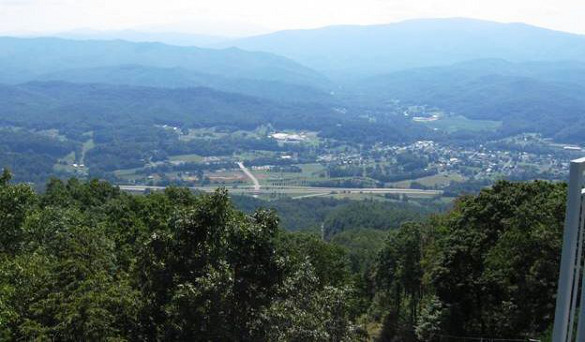
"The Valley Beautiful"
Eastern view from Pinnacle Mountain Tower
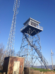 In 2011, Pinnacle Fire Tower was adapted from a wood and metal structure to an all-metal covered viewing
platform. The structure utilized the 40-foot tower structure and replaced the cab with a covered platform
the same size, shape and configuration as the old catwalk and cab. The platform offers views of the region's
highest peaks, including Unaka Mountain and Roan Mountain, as well as views into the towns of Johnson City, Unicoi
and Erwin.
The 4.8 hike/bike Pinnacle Mountain Trail serves as a destination trail to the tower. The trailhead, at the foot of Buffalo Mountain, provides convenient trail access from Interstate 26, Exit 32 in the Town of Unicoi. From this trailhead vantage point, Pinnacle Mountain Trail #25 winds its way up the mountain at grades the whole family can enjoy. As a result, the trail has quickly become one of Unicoi County's most popular.
For more information on how the Pinnacle Mountain Tower renovation and Trail came to be, see this April 19, 2010 News Announcement from the USDA Forest Service.
Tower Facts
- The lookout system began operating in the Cherokee National Forest in the late 1920s to early 1930s. Fire wardens from local communities played an important role in wildfire detection.
- A network of fire towers was built to overlook as much of the surrounding landscape as possible. Towers were located on high points, with 360-degree views and visibility of 10-15 miles.
- Some sites provided such good visibility that the tower structure could be lower, perhaps only one or two stories tall. Each individual tower was built to triangulate with at least two others.
- Lookout towers were constructed with a minimum of solid walls and a lot of glass. Some were constructed of native materials to blend in with the landscape, while others were merely functional and built of metal.
- Each tower was staffed by one or more lookouts during fire season, from fall through spring. The normal staffing season for wildfire detection in the Cherokee National Forest was Feb. 15-May 1 and Oct. 15-Dec. 1.
- Towers were equipped with an azimuth reader, made up of an area map mounted on a circular metal disk with degree notations along its circumference. Each tower and the central dispatch office were equipped with area maps that included tower locations. The exact location of smoke would be verified by pinpointing it from two or three sites, a process known as triangulating.
- Forest Service records indicate that the Pinnacle Mountain Fire Tower likely was constructed in 1931. In 1949, it was equipped with its first telephone.
- In the old days, the fire lookouts didn't only watch for smoke. They also recorded wind speed, humidity and temperature.
- At one time, there were as many as 18 fire towers throughout the Cherokee National Forest. Some had small cabs measuring 7 feet by 7 feet. Others, like the Pinnacle Mountain Tower, featured living quarters big enough for a cot, refrigerator and kitchen stove.
- By the late 1980s, regular staffing of the fire towers was discontinued as detection from airplanes proved more effective.
Trail Route Description
 The trailhead is located at the future site of the Tanasi Arts & Heritage Center in the Town of Unicoi's
Jack Snider Park next to Interstate 26 at Exit 32 in Unicoi, TN and is open year round to hiking or mountain bicycling
during daylight hours.
The lime green-blazed trail winds up to the top with a steady 6% to 7% slope using many switchbacks. The trail crosses a gravel road and ATV trail near the top (1.5 miles from tower) which also lead to the tower, but are steeper than the trail.
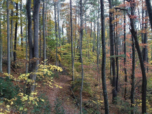 The total 9.6 mile round-trip trek takes 2 to 2.5 hours to hike up to the tower, and then 1.75 hours back down. Cut half hour
off descent by coming down gravel road way to trail intersection.
Most of the trail is through forest, whether along hillside or in draws. Under the canopy and along the trail, an impressive amount of wildflowers bloom throughout Spring, including Mountain Laurel, Mountain Stonecrop, Flame Azalea, and Pink Lady Slipper Orchids as well as many other species. In October, at the height of the Autumn season, the forest is an explosion of color from buttery golden yellow to vibrant reds.
Typical Trail Conditions
The new trail, mostly constructed by a Bobcat backhoe by a contractor, is 4 feet wide and well graded at 6% to 7% with a slight side-to-side slope to avoid water build-up on the path.
Conditions atop the Tower observation platform will be breezy.
There is no water or restroom facilities at the Tower Trail summit.
Temporary restroom facilities are at the Jack Snider Park trailhead with construction for more parking, pavilion/picnic area and permanent facilities in progress.
All of the above content was compiled from information obtained from:
- U.S. Forest Service information on Pinnacle Mountain Tower and Trail.
- Knoxville News Sentinel Nov. 2007 article and Nov. 2011 article.
- Tennessee Eastman Hiking & Canoeing Club Trail Wiki.
- Outdoor enthusiast submitted content at AllTrails.com
- The Monkey's Mask Presents: Getting Lost In Tennessee... website.
Trail Map
Use the zoom buttons to follow the trail to the tower from the trail head that is immediately north and west of the I-26 exit 32 ramp.
Mapping The Way
Two volunteers blaze a trail to the historic and remote Pinnacle Fire Tower
By Eileen Rush, Staff Writer
The Erwin Record, August 2008
They crept up the mountain with spring on their heels. In the harder months, February and March, dry leaves lay thick on the ground. As the retired postal service worker and the former Eastman chemical engineer made their way up the mountain's side, they had to be careful not to slip. Soccer cleats kept them from sliding off the mountain.
In the middle of July, Ed Oliver and Jim Foster tied their last pink ribbon to the last tree branch. The five-month-long flagging of a trail leading through Unicoi County and up to the iconic Pinnacle Tower was finally complete.
The historic forest ranger tower, which sits on a ridge overlooking the town of Unicoi, was used for many years by the U.S. Forest Service to keep watch for forest fires.
"We worked our way up the mountain as spring worked its way up the mountain," Oliver, a Kingsport native and retired Eastman Kodak Co. employee, said.
And, it wasn't easy.
While they worked slowly, sometimes crawling on their hands and knees or stepping over "blow-downs" - fallen trees - they saw wildflowers bloom and aged trees burst into an emerald green.
The two 62-year-old retirees would rather map trails than golf or attend a local "bingo night."
"I think volunteerism is something that gets in your blood," Foster said.
Yet, they are sometimes still baffled by their own love of the strenuous work of flagging, "rehabing" and relocating trails.
"We still haven't figured out why we like doing this so much," said Foster.
Foster now lives in Johnson City, but he grew up on Parsley Street in Erwin. As an Erwin native, he said that he understands why this trail leading to the Pinnacle Tower will be so important to the community.
Normally, the two men work restoring sections of the Appalachian Trail from Damascus, Va. to Spivey Gap in Earnestville, Tenn. When Sam Brocata, executive director of the non-profit organization Partners of the Cherokee National Forest, asked the volunteers if they would take on the Pinnacle Tower project, they accepted.
"They've taken this on as a project because the U.S. Forest Service doesn't have the funds to renovate the tower," said Sam Bowerman, who has worked for the U.S. Department of Agriculture for 31 years.
So far, the PCNF members have raised more than $20,000 to go towards the restoration of the Pinnacle Tower. The organization needs $100,000 to complete the project, Brocato said.
The trial's proximity to Johnson City, Erwin and Elizabethton, as well as its easy incline to walk - an average of a seven percent grade - should make it a popular outdoor experience, Brocato said.
When the trail is completed, it will total four miles in length and will be at least four feet wide. The wide trail and the long curves of the switchbacks will make it easier for mountain bikers to use the trail, Oliver said.
This is the first project that Oliver and Foster have ever taken on that has involved biking.
"It takes a lot of trail to get up a mountain at 6 percent (grade)," Oliver said.
Mapping out the trail was "slow going" for the men. The trail was completely flagged after 15 trips up the mountain. Another volunteer, Carl Fritz, helped to flag the trail on three trips while Foster was in Maine completing the Appalachian Trail.
On a map, the trail makes so many switch backs that it looks like a bear's claw. Although the hike is long and has multiple switchbacks, it should be fairly easy to hike due to the low grade.
Some days the volunteers would run into dead ends - private property lines, thick beds of rock, forest too dense to wade through. Those were the most frustrating days, Oliver said.
Most of the trail winds through forest, but there will be some openings on the trail with views of the mountains. Eventually those openings should have benches and bike racks for people to rest at, sit down and enjoy the view, Oliver said.
From the trail and from the Pinnacle Tower, hikers can see Unaka Mountain, Buffalo Mountain, Roan Mountain and on a clear day, mountains in North Carolina and Virginia. From the ridge where the tower sits, a view of I-26 and the town of Unicoi is crystal clear.
"I think it's nice to have those openings in the forest so you can get some views," Oliver said.
The trail will even cross through some small streams that run along the mountain. Part of the year, Oliver said, hikers will be able to hear the water against the rocks.
"The sound of water is so nice if you're hiking," he said.
The highlight of the hike is getting to the top and having a complete panoramic view of the mountains.
In order to make a donation to the Pinnacle Tower project, contact a Mountain Commerce Bank branch and ask to make a contribution to the Pinnacle Fire Tower Fund, Brocato said.
The PCNF awarded the volunteers with two gift cards to Mahoney's Outfitters in Johnson City on Aug. 14.
The cards were a way to say "thank you" for the work that was done, Brocato said.
However, the two volunteers look forward to the day that they will get a different kind of reward.
"Getting to walk that trail will be the best thanks," Foster said.
An original news article © 2008 The Erwin Record.
Reprinted with permission.
Trail Facts
- USFS Trail #25 "Pinnacle Mountain Tower Trail"
- Marking - Lime-Green
- Usage - Hiking/Mountain Bicycling
- Dogs - Permitted on 6-ft leash
- Hours - Day Use Only (sunrise to sunset)
- Season - Year Round
- Distance - 9.6 miles round trip
- Hiking Time - 4 hours
- High Point - 3520 feet elevation
- Elevation Gain - 1400 feet
- Difficulty - Moderate
Pinnacle Tower
The trailhead to Pinnacle Mountain Tower Trail is within close walking distance of the campground entrance.
Resources
Watauga Ranger District
4400 Unicoi Drive
Unicoi TN 37692
(423) 735-1500
(423) 735-7306 (Fax)


